Geolocate

Clagiraba topographic map

Click on the map to display elevation.

About this map

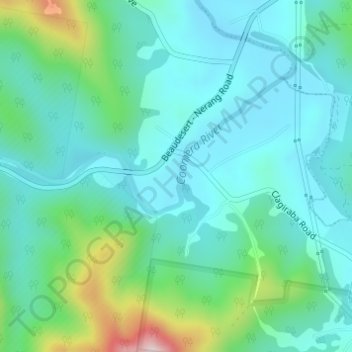
Name: Clagiraba topographic map, elevation, terrain.

Location: Clagiraba, Gold Coast, Queensland, Australia (-28.00055 153.23362 -27.98055 153.25362)

Average elevation: 122 m

Minimum elevation: 33 m

Maximum elevation: 452 m

Other topographic maps

Click on a map to view its topography, its elevation and its terrain.

Reedy Creek

Australia > Queensland > Gold Coast

Average elevation: 16 m

Kingsholme

Australia > Queensland > Gold Coast

Average elevation: 127 m

Gear up for your next adventure:

🔋Rechargeable Batteries - Eco-friendly power for headlamps and older GPS units
🧤Thermal Touchscreen Gloves - Stay warm while operating your GPS or smartphone camera
🧺Mesh Stuff Sacks - Breathable storage for wet gear or camp organization
👕Technical Hiking Tees - Moisture-management for high-exertion climbs
Altimeter Watches - Watches measuring altitude for mountain activities

As an Amazon Associate, this site earns from qualifying purchases at no extra cost to you.