
Godalming topographic map
Click on the map to display elevation.
Godalming
Elevations vary between 36 m (118 ft) AOD by the Guildford Road Rugby Union ground and Broadwater lake at the River Wey's exit from Godalming into Peasmarsh, Shalford, and 106 m (347.76 ft) AOD where Quarter Mile meets Hambledon Road (both residential) in the south-east. Hurtmore Road is also residential: Upper Green/Hurtmore is at 102 m (334.64 ft) AOD. Immediately north and south of the town centre, steep hills reach 95 m (311.67 ft) AOD from 40-45m (131.23-147.63 ft) AOD in the town centre itself.
About this map
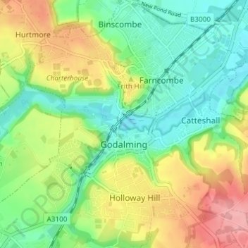
Name: Godalming topographic map, elevation, terrain.
Location: Godalming, Waverley, Surrey, England, United Kingdom (51.16986 -0.64093 51.20806 -0.58489)
Average elevation: 71 m
Minimum elevation: 31 m
Maximum elevation: 133 m
Surrey trails, hiking, mountain biking, running and outdoor activities
Other topographic maps
Click on a map to view its topography, its elevation and its terrain.
Hankley Common
United Kingdom > England > Surrey > Waverley > Thursley > Truxford
Average elevation: 70 m
Camelsdale
United Kingdom > England > Surrey > Waverley > Haslemere > Shottermill
Average elevation: 166 m
Floodplain (seasonal)
United Kingdom > England > Surrey > Waverley > Farnham > Wrecclesham
Average elevation: 94 m