
Mohnyin Township topographic map
Interactive map
Click on the map to display elevation.
About this map
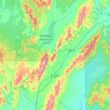
Name: Mohnyin Township topographic map, elevation, terrain.
Location: Mohnyin Township, Mohnyin District, Kachin, Myanmar (24.47977 95.80617 25.43046 96.80599)
Average elevation: 350 m
Minimum elevation: 94 m
Maximum elevation: 1,518 m
Other topographic maps
Click on a map to view its topography, its elevation and its terrain.