Geolocate

Turi topographic map

Click on the map to display elevation.

About this map
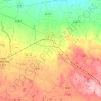
Name: Turi topographic map, elevation, terrain.

Location: Turi, Bari, Apulia, 70010, Italy (40.84545 16.96011 40.95838 17.06216)

Average elevation: 262 m

Minimum elevation: 177 m

Maximum elevation: 351 m

Other topographic maps

Click on a map to view its topography, its elevation and its terrain.

Impalata

Italy > Apulia > Bari > Monopoli

Average elevation: 269 m

Impalata

Italy > Apulia > Bari > Monopoli

Average elevation: 269 m

Altamura

Italy > Apulia > Bari > Altamura

Average elevation: 409 m

Polignano a Mare

Italy > Apulia > Bari

Average elevation: 42 m

Monte Belvedere

Italy > Apulia > Bari > Altamura

Average elevation: 456 m

Gear up for your next adventure:

🧤Waterproof Overmitts - Extreme weather protection for hikers and mountaineers
☕Insulated Travel Mugs - Keep drinks hot while surveying the landscape from a summit
🥾Walking Shoes - Lightweight walking shoes for countryside and coastal paths
🖼️Topographic Map Art - Decorative 3D-effect posters of famous UK peaks and regions
🎿Telescopic Trekking Poles - Reduces knee strain on steep topographic descents

As an Amazon Associate, this site earns from qualifying purchases at no extra cost to you.