
Make a donation
Gear up for your next adventure:
As an Amazon Associate, this site earns from qualifying purchases at no extra cost to you.
Benaoján topographic map
Click on the map to display elevation.
Make a donation
Gear up for your next adventure:
As an Amazon Associate, this site earns from qualifying purchases at no extra cost to you.
Benaoján
Benaoján (Spanish pronunciation: [be.na.oˈxan]) is a town and municipality in the province of Málaga, part of the autonomous community of Andalusia in southern Spain. It is located within the Sierra de Grazalema Natural Park. Its surface area is 32 km2. The municipality is situated approximately 17 kilometers from Ronda and 116 km from the capital of the province. It is situated at an altitude of 524 meters. Its inhabitants are called benaojanos.
Make a donation
Gear up for your next adventure:
As an Amazon Associate, this site earns from qualifying purchases at no extra cost to you.
About this map
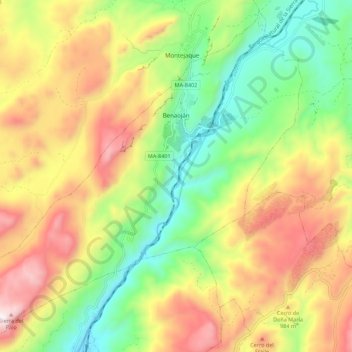
Name: Benaoján topographic map, elevation, terrain.
Location: Benaoján, Serranía de Ronda, Malaga, Andalusia, 29370, Spain (36.66208 -5.32403 36.74469 -5.21391)
Average elevation: 836 m
Minimum elevation: 385 m
Maximum elevation: 1,392 m
Make a donation
Gear up for your next adventure:
As an Amazon Associate, this site earns from qualifying purchases at no extra cost to you.