
Te Manga topographic map
Interactive map
Click on the map to display elevation.
About this map
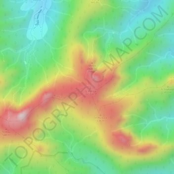
Name: Te Manga topographic map, elevation, terrain.
Location: Te Manga, Takitumu, Rarotonga, Cook Islands (-21.23563 -159.76399 -21.23553 -159.76389)
Average elevation: 265 m
Minimum elevation: 51 m
Maximum elevation: 537 m
Other topographic maps
Click on a map to view its topography, its elevation and its terrain.
Oneroa
Cook Islands > Rarotonga > Takitumu > Muri
Oneroa, Muri, Takitumu, Rarotonga, Cook Islands
Average elevation: 15 m