
Khan Shaykhun topographic map
Interactive map
Click on the map to display elevation.
Khan Shaykhun
Khan Shaykhun is located at an altitude of 350 meters on the main highway between Aleppo and Damascus. The local economy is primarily agricultural, focusing on the growing of cotton and cereals. The town was formerly known for producing embroidery. Nearby localities include Hbit to the west, Kafr Zita to southwest, Murak to the south and Al-Tamanah to the east. In 2004, it was recorded as having 34,371 inhabitants.
About this map
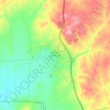
Name: Khan Shaykhun topographic map, elevation, terrain.
Average elevation: 385 m
Minimum elevation: 311 m
Maximum elevation: 480 m
Other topographic maps
Click on a map to view its topography, its elevation and its terrain.