
Treia topographic map
Interactive map
Click on the map to display elevation.
About this map
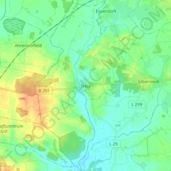
Name: Treia topographic map, elevation, terrain.
Average elevation: 11 m
Minimum elevation: -1 m
Maximum elevation: 34 m
Roman Trea was situated along an important byroad of the via Flaminia, which connected Rome directly to the harbour city Ancona, via most of the Potenza Valley. Around this road a street-side settlement developed gradually into a real town during the Late Republic. The town wall delimiting the main urban area has an irregular oval shape, which agrees well with the general topographic configuration of the hilly plateau. The total enclosed area is only about 11 ha but possibly extramural habitation areas existed, particularly on the eastern and western sides. The street grid, individuating insulae of different size, is organized parallel with and perpendicular to a central decumanus maximus. Centrally the main road is interrupted by the monumental forum complex. The open rectangular square, is bordered by porticoes, tabernae and a series of public buildings. Centrally on the eastern side stood a rectangular building identified as the main podium temple. On and near the short west side of the forum stood a basilica, and possibly a curia. The planned forum was probably constructed in late Republican and early Imperial times. The remnants of another temple, discovered under the bell tower of the sanctuary of SS. Crocifisso and partly excavated by the University of Macerata in the 1980s, can be considered as an Egyptian sanctuary for Isis and Serapis. The discovery of a marble head of Serapis and a number of smaller Egyptian statuettes, as well as the second century AD inscription that mentions the temple of the “Domina” (the goddess Isis), can lead to the interpretation that this foreign cult was practiced here.