
Indus River (branch) topographic map
Interactive map
Click on the map to display elevation.
About this map
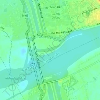
Name: Indus River (branch) topographic map, elevation, terrain.
Location: Indus River (branch), Sukkur, Sindh, Pakistan (27.67783 68.84184 27.68758 68.86055)
Average elevation: 61 m
Minimum elevation: 52 m
Maximum elevation: 78 m
Other topographic maps
Click on a map to view its topography, its elevation and its terrain.
Indus River
Indus River, Lab-e-Mehran Road, Old Sukkur, Sukkur, Shikārpur District, Sindh, Pakistan
Average elevation: 64 m
District & Sessions Court Sukkur
District & Sessions Court Sukkur, Sukkur, Sindh, Pakistan
Average elevation: 65 m
Indus River
Indus River, Lab-e-Mehran Road, Old Sukkur, Sukkur, Shikārpur District, Sindh, Pakistan
Average elevation: 64 m