
Make a donation
Gear up for your next adventure:
As an Amazon Associate, this site earns from qualifying purchases at no extra cost to you.
Blue Mountain Peak topographic map
Click on the map to display elevation.
Make a donation
Gear up for your next adventure:
As an Amazon Associate, this site earns from qualifying purchases at no extra cost to you.
Blue Mountain Peak
The Blue Mountains are popular for hiking and camping. The traditional Blue Mountain trek is a 7-mile (11 km) hike to the peak and consists of a 3,000-foot (910 m) increase in elevation. Jamaicans prefer to reach the peak at sunrise, thus the 3- to 4-hour hike is usually undertaken in darkness. Since the sky is usually very clear in the mornings, Cuba can be seen in the distance.
Make a donation
Gear up for your next adventure:
As an Amazon Associate, this site earns from qualifying purchases at no extra cost to you.
About this map
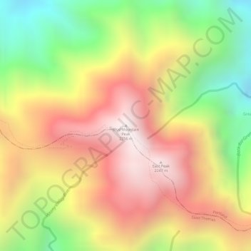
Name: Blue Mountain Peak topographic map, elevation, terrain.
Location: Blue Mountain Peak, Portland, Surrey County, Jamaica (18.04701 -76.57898 18.04711 -76.57888)
Average elevation: 1,808 m
Minimum elevation: 1,278 m
Maximum elevation: 2,234 m
Make a donation
Gear up for your next adventure:
As an Amazon Associate, this site earns from qualifying purchases at no extra cost to you.