Geolocate

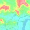
Netravati topographic map

Click on the map to display elevation.

About this map

Name: Netravati topographic map, elevation, terrain.

Location: Netravati, Bantwal taluk, Dakshina Kannada, Karnataka, India (12.83690 74.82702 13.13412 75.37177)

Average elevation: 208 m

Minimum elevation: 0 m

Maximum elevation: 1,872 m

Other topographic maps

Click on a map to view its topography, its elevation and its terrain.

Kalladka

India > Karnataka > Bantwal taluk

Average elevation: 43 m

Virakamba

India > Karnataka > Bantwal taluk

Average elevation: 99 m

Amtadi

India > Karnataka > Bantwal taluk > Bantwal

Average elevation: 54 m

Gear up for your next adventure:

🧢Waterproof Hiking Hats - Keep the rain off your face while studying topographic maps
❄️Walking Crampons - Added traction for icy slopes and winter peak bagging
🧼Camping Hygiene Kits - Compact hygiene essentials for outdoor stays
📸Action Camera Chest Mounts - Record your ascent following topographic paths hands-free
📐Altimeters & Barometers - Tools for measuring altitude and air pressure

As an Amazon Associate, this site earns from qualifying purchases at no extra cost to you.