
Wandoor topographic map
Interactive map
Click on the map to display elevation.
Wandoor
Wandoor is located in the central area of Malappuram District. The State Highway 73 passes through the town. Its average elevation is 48 metres above the sea level.
About this map
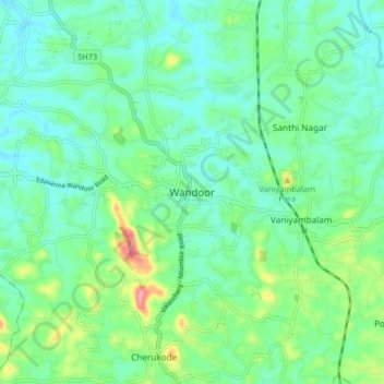
Name: Wandoor topographic map, elevation, terrain.
Location: Wandoor, Nilambur, Malappuram, Kerala, 679328, India (11.15574 76.19688 11.23574 76.27688)
Average elevation: 48 m
Minimum elevation: 18 m
Maximum elevation: 138 m
Other topographic maps
Click on a map to view its topography, its elevation and its terrain.
Nilambur
The 2,554 m (8,379 ft) m high Mukurthi peak, which is situated in the border of Nilambur Taluk and Ooty Taluk, and is also the fifth-highest peak in South India as well as the third-highest in Kerala after Anamudi (2,696 m [8,845 ft]) and Meesapulimala (2,651 m [8,698 ft]), is the highest point of elevation in…
Average elevation: 33 m