
Make a donation
Gear up for your next adventure:
As an Amazon Associate, this site earns from qualifying purchases at no extra cost to you.
Wandoor topographic map
Click on the map to display elevation.
Make a donation
Gear up for your next adventure:
As an Amazon Associate, this site earns from qualifying purchases at no extra cost to you.
Wandoor
Wandoor is located in the central area of Malappuram District. The State Highway 73 passes through the town. Its average elevation is 48 metres above the sea level.
Make a donation
Gear up for your next adventure:
As an Amazon Associate, this site earns from qualifying purchases at no extra cost to you.
About this map
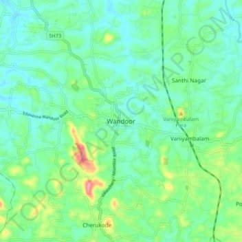
Name: Wandoor topographic map, elevation, terrain.
Location: Wandoor, Nilambur, Malappuram, Kerala, 679328, India (11.15574 76.19688 11.23574 76.27688)
Average elevation: 48 m
Minimum elevation: 18 m
Maximum elevation: 138 m
Make a donation
Gear up for your next adventure:
As an Amazon Associate, this site earns from qualifying purchases at no extra cost to you.
Other topographic maps
Click on a map to view its topography, its elevation and its terrain.