Geolocate

Estanza topographic map

Click on the map to display elevation.

About this map

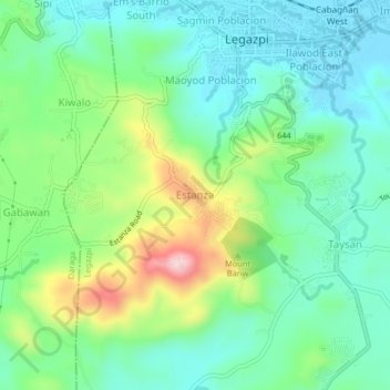
Name: Estanza topographic map, elevation, terrain.

Location: Estanza, Legazpi, Albay, Bicol Region, 4501, Philippines (13.10284 123.70884 13.14284 123.74884)

Average elevation: 81 m

Minimum elevation: 3 m

Maximum elevation: 266 m

Other topographic maps

Click on a map to view its topography, its elevation and its terrain.

Mayon Volcano

Philippines > Albay > Legazpi

Average elevation: 519 m

Sawangan Park

Philippines > Albay > Legazpi

Average elevation: 7 m

Kalayaan Park

Philippines > Albay > Legazpi

Average elevation: 7 m

Gear up for your next adventure:

Camping Shelters - Emergency and lightweight shelters for outdoor use
🎒Hiking Backpacks - Comfortable backpacks for day hikes and multi-day treks
🧘Folding Sit Mats - Dry and warm seat for map-reading breaks on damp ground
🛌Sleeping Mats - Insulated mats for comfortable outdoor sleeping
👕Merino Base Layers - Natural temperature regulation for cold weather hiking and camping

As an Amazon Associate, this site earns from qualifying purchases at no extra cost to you.