Geolocate

Dhamwari topographic map

Click on the map to display elevation.

About this map

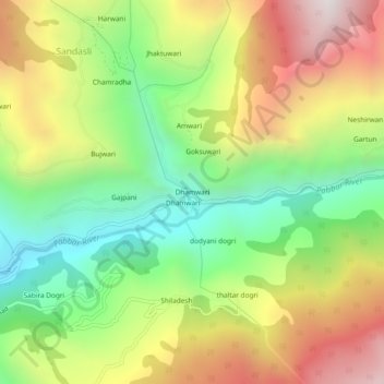
Name: Dhamwari topographic map, elevation, terrain.

Location: Dhamwari, Chirgaon, Shimla district, Himachal Pradesh, India (31.23375 77.93791 31.27375 77.97791)

Average elevation: 2,486 m

Minimum elevation: 1,911 m

Maximum elevation: 3,208 m

Gear up for your next adventure:

🧼Camping Hygiene Kits - Compact hygiene essentials for outdoor stays
📦Dry Bags - Waterproof bags to protect gear from rain
🧭GPS Trackers - Tracking devices for safety and navigation
🧺Ultralight Dry Bags - Organize and waterproof your gear inside your rucksack
🦯Walking Poles - Supportive poles for long-distance walking

As an Amazon Associate, this site earns from qualifying purchases at no extra cost to you.