
Wiehe topographic map
Interactive map
Click on the map to display elevation.
About this map
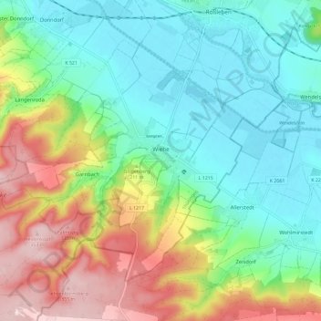
Name: Wiehe topographic map, elevation, terrain.
Location: Wiehe, Roßleben-Wiehe, Kyffhäuserkreis, Thuringia, Germany (51.23657 11.34040 51.29093 11.45601)
Average elevation: 196 m
Minimum elevation: 111 m
Maximum elevation: 361 m
Other topographic maps
Click on a map to view its topography, its elevation and its terrain.
Langenroda
Germany > Thuringia > Kyffhäuserkreis
Langenroda, Wiehe, Roßleben-Wiehe, Kyffhäuserkreis, Thuringia, Germany
Average elevation: 236 m
Artern
Germany > Thuringia > Kyffhäuserkreis
Artern, Kyffhäuserkreis, Thuringia, 06556, Germany
Average elevation: 131 m
Ichstedt
Germany > Thuringia > Kyffhäuserkreis > Bad Frankenhausen/Kyffhäuser
Ichstedt, Bad Frankenhausen/Kyffhäuser, Kyffhäuserkreis, Thuringia, Germany
Average elevation: 175 m
Sondershausen
Germany > Thuringia > Kyffhäuserkreis
Sondershausen, Kyffhäuserland, Kyffhäuserkreis, Thuringia, 99707, Germany
Average elevation: 273 m
Voigtstedt
Germany > Thuringia > Kyffhäuserkreis > Artern
Voigtstedt, Artern, Kyffhäuserkreis, Thuringia, Germany
Average elevation: 134 m