Geolocate

Liberty topographic map

Click on the map to display elevation.

About this map

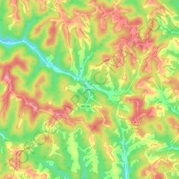
Name: Liberty topographic map, elevation, terrain.

Location: Liberty, Putnam County, West Virginia, 25124, United States (38.58509 -81.74985 38.62509 -81.70985)

Average elevation: 281 m

Minimum elevation: 218 m

Maximum elevation: 331 m

Other topographic maps

Click on a map to view its topography, its elevation and its terrain.

Eleanor

United States > West Virginia > Putnam County

Average elevation: 213 m

Hurricane

United States > West Virginia > Putnam County

Average elevation: 237 m

Winfield

United States > West Virginia > Putnam County

Average elevation: 223 m

Poca

United States > West Virginia > Putnam County

Average elevation: 216 m

Winfield

United States > West Virginia > Putnam County

Average elevation: 223 m

Eleanor

United States > West Virginia > Putnam County

Average elevation: 213 m

Gear up for your next adventure:

🗺️Topographic Maps - Detailed maps showing elevation and terrain features
🧦Hiking Socks - Breathable socks designed to prevent blisters on long walks
🎒Backpack Rain Covers - Universal waterproof covers to protect your gear from downpours
🛌Sleeping Mats - Insulated mats for comfortable outdoor sleeping
Altimeter Watches - Watches measuring altitude for mountain activities

As an Amazon Associate, this site earns from qualifying purchases at no extra cost to you.