
Owltown topographic map
Interactive map
Click on the map to display elevation.
About this map
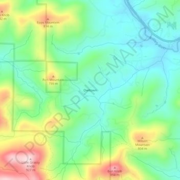
Name: Owltown topographic map, elevation, terrain.
Location: Owltown, Union County, Georgia, United States (34.79315 -83.95991 34.83315 -83.91991)
Average elevation: 678 m
Minimum elevation: 559 m
Maximum elevation: 920 m
Other topographic maps
Click on a map to view its topography, its elevation and its terrain.
Blairsville
United States > Georgia > Union County
Blairsville, Georgia, is situated in the picturesque Appalachian Mountains, characterized by a varied topography that includes rolling hills, lush valleys, and prominent mountain ridges. The elevation of the town itself is approximately 1,800 feet, providing breathtaking views of the surrounding landscape. The…
Average elevation: 587 m
Blairsville
United States > Georgia > Union County
Blairsville has a humid subtropical climate, yet due to its elevation of 1,883 feet (574 m), typically records far lower temperatures at night than what is encountered in much of the Southeastern U.S., and has slightly higher precipitation totals (56 inches or 1,420 millimetres annually) than most locations in…
Average elevation: 587 m