
Thank you for supporting this site ❤️
Make a donation
Make a donation
Gear up for your next adventure:
As an Amazon Associate, this site earns from qualifying purchases at no extra cost to you.
Cosenza topographic map
Click on the map to display elevation.
Thank you for supporting this site ❤️
Make a donation
Make a donation
Gear up for your next adventure:
As an Amazon Associate, this site earns from qualifying purchases at no extra cost to you.
About this map
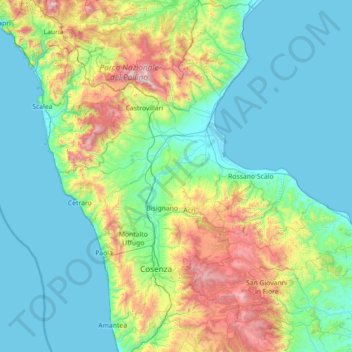
Name: Cosenza topographic map, elevation, terrain.
Location: Cosenza, Calabria, Italy (39.04870 15.75642 40.14492 17.02367)
Average elevation: 408 m
Minimum elevation: -1 m
Maximum elevation: 2,241 m
Thank you for supporting this site ❤️
Make a donation
Make a donation
Gear up for your next adventure:
As an Amazon Associate, this site earns from qualifying purchases at no extra cost to you.
Other topographic maps
Click on a map to view its topography, its elevation and its terrain.
Sant'Antonio
Italy > Calabria > Crotone > Isola di Capo Rizzuto > Sant'Antonio
Average elevation: 22 m