
Make a donation
Gear up for your next adventure:
As an Amazon Associate, this site earns from qualifying purchases at no extra cost to you.
Bala Cynwyd topographic map
Click on the map to display elevation.
Make a donation
Gear up for your next adventure:
As an Amazon Associate, this site earns from qualifying purchases at no extra cost to you.
About this map
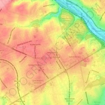
Name: Bala Cynwyd topographic map, elevation, terrain.
Average elevation: 75 m
Minimum elevation: 6 m
Maximum elevation: 113 m
Make a donation
Gear up for your next adventure:
As an Amazon Associate, this site earns from qualifying purchases at no extra cost to you.
Other topographic maps
Click on a map to view its topography, its elevation and its terrain.
Ardmore
United States > Pennsylvania > Montgomery County > Lower Merion Township > Ardmore
Average elevation: 99 m
Bryn Mawr
United States > Pennsylvania > Montgomery County > Lower Merion Township > Bryn Mawr
Average elevation: 117 m
Ardmore
United States > Pennsylvania > Montgomery County > Lower Merion Township > Ardmore
Average elevation: 99 m
Bryn Mawr
United States > Pennsylvania > Montgomery County > Lower Merion Township > Rosemont
Average elevation: 117 m
Make a donation
Gear up for your next adventure:
As an Amazon Associate, this site earns from qualifying purchases at no extra cost to you.