Geolocate

Constitution topographic map

Click on the map to display elevation.

About this map

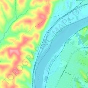
Name: Constitution topographic map, elevation, terrain.

Location: Constitution, Washington County, Ohio, 25105, United States (39.32813 -81.57457 39.36813 -81.53457)

Average elevation: 216 m

Minimum elevation: 177 m

Maximum elevation: 295 m

Other topographic maps

Click on a map to view its topography, its elevation and its terrain.

Devola

United States > Ohio > Washington County

Average elevation: 218 m

Marietta

United States > Ohio > Washington County

Average elevation: 215 m

Belpre

United States > Ohio > Washington County

Average elevation: 206 m

Lowell

United States > Ohio > Washington County

Average elevation: 222 m

Duck Creek

United States > Ohio > Washington County > Marietta

Average elevation: 242 m

Beverly

United States > Ohio > Washington County

Average elevation: 215 m

Marietta

United States > Ohio > Washington County

Average elevation: 215 m

Duck Creek

United States > Ohio > Washington County > Marietta

Average elevation: 242 m

Gear up for your next adventure:

🧥Breathable Waterproof Jackets - Essential rain protection for the unpredictable British climate
🧵Survival Paracord - Multi-purpose cordage for emergency repairs and shelters
🧴Tick Removal Tools - Small, essential health tool for UK woodland and moorland
🧊Personal Water Filters - Drink safely from mountain streams marked on your map
🛌Sleeping Mats - Insulated mats for comfortable outdoor sleeping

As an Amazon Associate, this site earns from qualifying purchases at no extra cost to you.