
Jette topographic map
Click on the map to display elevation.
About this map
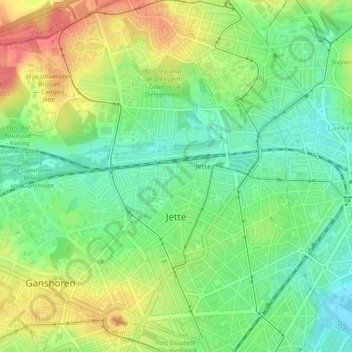
Name: Jette topographic map, elevation, terrain.
Location: Jette, Brussels-Capital, 1090, Belgium (50.86451 4.29376 50.89415 4.34067)
Average elevation: 45 m
Minimum elevation: 17 m
Maximum elevation: 81 m
Other topographic maps
Click on a map to view its topography, its elevation and its terrain.
Woluwe Park
Belgium > Brussels-Capital > Woluwe-Saint-Pierre - Sint-Pieters-Woluwe
Average elevation: 73 m
Boitsfort - Bosvoorde
Belgium > Brussels-Capital > Watermael-Boitsfort - Watermaal-Bosvoorde
Average elevation: 96 m
Parc de Laeken - Park van Laken
Belgium > Brussels-Capital > Brussels > Laeken - Laken
Average elevation: 47 m
Molenbeek-Saint-Jean - Sint-Jans-Molenbeek
Belgium > Brussels-Capital > Molenbeek-Saint-Jean - Sint-Jans-Molenbeek
Average elevation: 47 m