
Turze topographic map
Interactive map
Click on the map to display elevation.
About this map
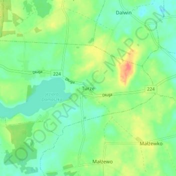
Name: Turze topographic map, elevation, terrain.
Average elevation: 73 m
Minimum elevation: 55 m
Maximum elevation: 107 m
Other topographic maps
Click on a map to view its topography, its elevation and its terrain.
Tczew
Poland > Pomeranian Voivodeship > Tczew County
Tczew, Tczew County, Pomeranian Voivodeship, 83-110, Poland
Average elevation: 16 m
Gniew
Poland > Pomeranian Voivodeship > Tczew County
Gniew, gmina Gniew, Tczew County, Pomeranian Voivodeship, 83-140, Poland
Average elevation: 33 m
Opalenie
Poland > Pomeranian Voivodeship > Tczew County
Opalenie, gmina Gniew, Tczew County, Pomeranian Voivodeship, 83-136, Poland
Average elevation: 35 m
Tczew
Poland > Pomeranian Voivodeship > Tczew County > Tczew
Tczew, Tczew County, Pomeranian Voivodeship, 83-110, Poland
Average elevation: 21 m