
Make a donation
Gear up for your next adventure:
As an Amazon Associate, this site earns from qualifying purchases at no extra cost to you.
Mammoth Lake topographic map
Click on the map to display elevation.
Make a donation
Gear up for your next adventure:
As an Amazon Associate, this site earns from qualifying purchases at no extra cost to you.
About this map
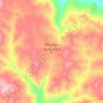
Name: Mammoth Lake topographic map, elevation, terrain.
Location: Mammoth Lake, Merced County, California, United States (37.04281 -121.19368 37.04430 -121.19204)
Average elevation: 399 m
Minimum elevation: 219 m
Maximum elevation: 484 m
Make a donation
Gear up for your next adventure:
As an Amazon Associate, this site earns from qualifying purchases at no extra cost to you.
Other topographic maps
Click on a map to view its topography, its elevation and its terrain.
Los Banos
United States > California > Merced County
Los Banos is located on the west side of the San Joaquin Valley, 26 miles (42 km) southwest of Merced, at approximately 118 ft (36 m) elevation. Its coordinates are 37°03′30″N 120°51′00″W / 37.05833°N 120.85000°W / 37.05833; -120.85000. The city is at the intersection of California State…
Average elevation: 35 m
Hilmar
United States > California > Merced County
Hilmar is an unincorporated community in Merced County, California, United States. It is located 4.25 miles (6.8 km) west-southwest of Delhi, spanning 3.9 sq mi (10 km2) and at an elevation of 92 ft (28 m) above sea level. For census purposes, Hilmar is aggregated with a nearby community into the Hilmar-Irwin…
Average elevation: 30 m
Dos Palos
United States > California > Merced County
Dos Palos (Spanish for "Two Timbers") is a city in Merced County, California, United States. Dos Palos is located 27 miles (43 km) south-southwest of Merced, the county seat, at an elevation of 118 feet (36 m). The population was 5,798 at the 2020 census, up from 4,950 at the 2010 census.
Average elevation: 35 m
Livingston
United States > California > Merced County
Livingston is a city in Merced County, California, United States. Livingston is located 7 miles (11 km) west-northwest of Atwater, at an elevation of 131 feet (40 m). According to the 2020 census, the city population was 14,172, up from 13,058 in 2010. Livingston's total area is 3.7 square miles (9.6 km2),…
Average elevation: 41 m
Make a donation
Gear up for your next adventure:
As an Amazon Associate, this site earns from qualifying purchases at no extra cost to you.
Atwater
United States > California > Merced County
Atwater is a city on State Route 99 in Merced County, California, United States. Atwater is 8 miles (13 km) west-northwest of Merced, at an elevation of 151 feet (46 m). The population as of the 2020 census was 31,970, up from 28,168 in 2010.
Average elevation: 49 m
Gustine
United States > California > Merced County
Gustine is a city in Merced County, California. Gustine is located 29 miles (47 km) west of Merced, at an elevation of 98 feet (30 m). At the 2020 census, the city population was 6,110, up from 5,520 at the 2010 census.
Average elevation: 30 m
Make a donation
Gear up for your next adventure:
As an Amazon Associate, this site earns from qualifying purchases at no extra cost to you.
Make a donation
Gear up for your next adventure:
As an Amazon Associate, this site earns from qualifying purchases at no extra cost to you.
Los Banos
United States > California > Merced County
Los Banos is located on the west side of the San Joaquin Valley, 26 miles (42 km) southwest of Merced, at about 118 ft (36 m) elevation. Its coordinates are 37°03′30″N 120°51′00″W / 37.05833°N 120.85000°W / 37.05833; -120.85000. The city is at the intersection of California State Route 152…
Average elevation: 36 m
Le Grand
United States > California > Merced County
Le Grand (also Legrand) is an unincorporated community and census-designated place (CDP) in Merced County, California, United States. Le Grand is 14 miles (23 km) east-southeast of Merced, the county seat at an elevation of 253 feet (77 m). The population was 1,592 at the 2020 census, down from 1,659 at the…
Average elevation: 78 m
Los Banos
United States > California > Merced County
Los Banos is located on the west side of the San Joaquin Valley, 26 miles (42 km) southwest of Merced, at about 118 ft (36 m) elevation. Its coordinates are 37°03′30″N 120°51′00″W / 37.05833°N 120.85000°W / 37.05833; -120.85000. The city is at the intersection of California State Route 152…
Average elevation: 35 m
Atwater
United States > California > Merced County
Atwater is a city on State Route 99 in Merced County, California, United States. Atwater is 8 miles (13 km) west-northwest of Merced, at an elevation of 151 feet (46 m). The population as of the 2020 census was 31,970, up from 28,168 in 2010.
Average elevation: 50 m
Make a donation
Gear up for your next adventure:
As an Amazon Associate, this site earns from qualifying purchases at no extra cost to you.
Gustine
United States > California > Merced County
Gustine is a city in Merced County, California. Gustine is located 29 miles (47 km) west of Merced, at an elevation of 98 feet (30 m). At the 2020 census, the city population was 6,110, up from 5,520 at the 2010 census.
Average elevation: 30 m