
Make a donation
Gear up for your next adventure:
As an Amazon Associate, this site earns from qualifying purchases at no extra cost to you.
Victoria-Fraserview topographic map
Click on the map to display elevation.
Make a donation
Gear up for your next adventure:
As an Amazon Associate, this site earns from qualifying purchases at no extra cost to you.
About this map
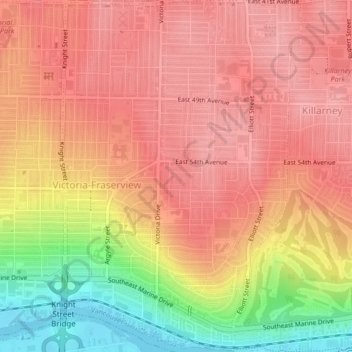
Name: Victoria-Fraserview topographic map, elevation, terrain.
Average elevation: 67 m
Minimum elevation: -2 m
Maximum elevation: 104 m
Make a donation
Gear up for your next adventure:
As an Amazon Associate, this site earns from qualifying purchases at no extra cost to you.
Other topographic maps
Click on a map to view its topography, its elevation and its terrain.
Livingstone Lake
Canada > British Columbia > Metro Vancouver Regional District > Vancouver
Average elevation: 86 m
Stanley Park
Canada > British Columbia > Metro Vancouver Regional District > Vancouver
Average elevation: 14 m
Jericho Beach
Canada > British Columbia > Metro Vancouver Regional District > Vancouver
Average elevation: 20 m
Trout Lake
Canada > British Columbia > Metro Vancouver Regional District > Vancouver
Average elevation: 52 m
Make a donation
Gear up for your next adventure:
As an Amazon Associate, this site earns from qualifying purchases at no extra cost to you.
Little Mountain
Canada > British Columbia > Metro Vancouver Regional District > Vancouver
Little Mountain, elevation 125 m (410 ft), is a mountain in the central part of the city of Vancouver, British Columbia, Canada. The mountain is home to Queen Elizabeth Park, which sits at the top of the mountain, and Nat Bailey Stadium, which is located near the base. The mountain lends its name to the Riley…
Average elevation: 81 m
Queen Elizabeth Park
Canada > British Columbia > Metro Vancouver Regional District > Vancouver
Average elevation: 81 m
Strathcona Park
Canada > British Columbia > Metro Vancouver Regional District > Vancouver
Average elevation: 17 m
Still Creek
Canada > British Columbia > Metro Vancouver Regional District > Vancouver
Average elevation: 65 m
Make a donation
Gear up for your next adventure:
As an Amazon Associate, this site earns from qualifying purchases at no extra cost to you.
English Bay Beach
Canada > British Columbia > Metro Vancouver Regional District > Vancouver
Average elevation: 12 m
Slocan Park
Canada > British Columbia > Metro Vancouver Regional District > Vancouver
Average elevation: 81 m
Fraser River Park
Canada > British Columbia > Metro Vancouver Regional District > Vancouver
Average elevation: 19 m
Andy Livingstone Park
Canada > British Columbia > Metro Vancouver Regional District > Vancouver
Average elevation: 12 m
Make a donation
Gear up for your next adventure:
As an Amazon Associate, this site earns from qualifying purchases at no extra cost to you.
Kensington Park
Canada > British Columbia > Metro Vancouver Regional District > Vancouver
Average elevation: 81 m
Cambie Park
Canada > British Columbia > Metro Vancouver Regional District > Vancouver
Average elevation: 61 m
Charleson Park
Canada > British Columbia > Metro Vancouver Regional District > Vancouver
Average elevation: 28 m
Gaston Park
Canada > British Columbia > Metro Vancouver Regional District > Vancouver
Average elevation: 104 m
Make a donation
Gear up for your next adventure:
As an Amazon Associate, this site earns from qualifying purchases at no extra cost to you.
Brewers Park
Canada > British Columbia > Metro Vancouver Regional District > Vancouver
Average elevation: 64 m
Point Grey Park Site at Trutch Street
Canada > British Columbia > Metro Vancouver Regional District > Vancouver
Average elevation: 15 m
McBride Park
Canada > British Columbia > Metro Vancouver Regional District > Vancouver
Average elevation: 22 m
Queen Elizabeth Park
Canada > British Columbia > Metro Vancouver Regional District > Vancouver
Average elevation: 81 m
Make a donation
Gear up for your next adventure:
As an Amazon Associate, this site earns from qualifying purchases at no extra cost to you.
Queen Elizabeth Park
Canada > British Columbia > Metro Vancouver Regional District > Vancouver
Average elevation: 81 m
Stanley Park
Canada > British Columbia > Metro Vancouver Regional District > Vancouver
Average elevation: 14 m