
Make a donation
Gear up for your next adventure:
As an Amazon Associate, this site earns from qualifying purchases at no extra cost to you.
Sussex topographic map
Click on the map to display elevation.
Make a donation
Gear up for your next adventure:
As an Amazon Associate, this site earns from qualifying purchases at no extra cost to you.
Sussex
Sussex is a village in Waukesha County, Wisconsin, United States, about 19 miles (31 km) northwest of Milwaukee and 9 miles (14 km) north of Waukesha. The village is 7.24 square miles (19 km2) at an elevation of 930 feet. The population was 11,487 at the 2020 census. It is part of the Milwaukee metropolitan area.
Make a donation
Gear up for your next adventure:
As an Amazon Associate, this site earns from qualifying purchases at no extra cost to you.
About this map
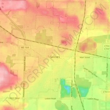
Name: Sussex topographic map, elevation, terrain.
Location: Sussex, Waukesha County, Wisconsin, United States (43.10682 -88.26398 43.16281 -88.18510)
Average elevation: 286 m
Minimum elevation: 210 m
Maximum elevation: 334 m
Make a donation
Gear up for your next adventure:
As an Amazon Associate, this site earns from qualifying purchases at no extra cost to you.
Other topographic maps
Click on a map to view its topography, its elevation and its terrain.
Menomonee Falls
United States > Wisconsin > Waukesha County > Menomonee Falls
Average elevation: 260 m
Make a donation
Gear up for your next adventure:
As an Amazon Associate, this site earns from qualifying purchases at no extra cost to you.