Geolocate

Addington Parish topographic map

Click on the map to display elevation.

About this map

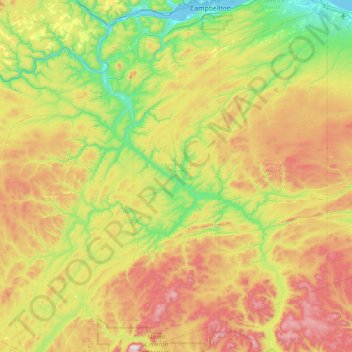
Name: Addington Parish topographic map, elevation, terrain.

Location: Addington Parish, Restigouche Rural District, Restigouche County, New Brunswick, Canada (47.39932 -66.90902 48.01837 -66.65372)

Average elevation: 293 m

Minimum elevation: -2 m

Maximum elevation: 765 m

Gear up for your next adventure:

📱Rugged Phone Cases - Heavy-duty protection for smartphones used as secondary GPS tools
👖Convertible Hiking Trousers - Versatile zip-off pants for changing mountain weather conditions
🔥Reusable Hand Warmers - Maintain dexterity in your fingers for precise map handling
🚲Bikepacking Frame Bags - Storage for tools and navigation gear on long off-road rides
🧭Professional Hiking Compasses - High-precision liquid-filled compasses for map reading and orientation

As an Amazon Associate, this site earns from qualifying purchases at no extra cost to you.