
Brezovica topographic map
Interactive map
Click on the map to display elevation.
Brezovica
The municipality lies at an altitude of 456 metres (1525.59 feet) and covers an area of 18.235 km² (7 mi²). It has a population of about 1700 people.
About this map
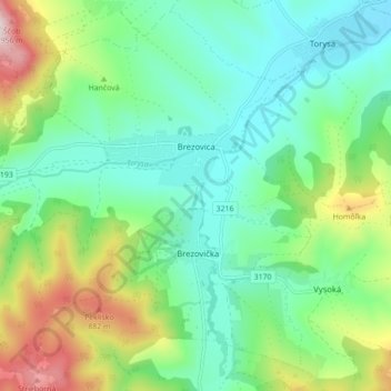
Name: Brezovica topographic map, elevation, terrain.
Average elevation: 589 m
Minimum elevation: 413 m
Maximum elevation: 1,023 m
Other topographic maps
Click on a map to view its topography, its elevation and its terrain.