Geolocate

Canary Islands topographic map

Interactive map

Click on the map to display elevation.

Canary Islands

The Canary Islands, especially Tenerife, Gran Canaria, Fuerteventura, and Lanzarote, are a major tourist destination, with over 12 million visitors per year. This is due to their beaches, subtropical climate, and important natural attractions, especially Maspalomas in Gran Canaria, Teide National Park, and Mount Teide (a World Heritage Site) in Tenerife. Mount Teide is the highest peak in Spain and the third tallest volcano in the world, measured from its base on the ocean floor. The islands have warm summers and winters warm enough for the climate to be technically tropical at sea level. The amount of precipitation and the level of maritime moderation vary depending on location and elevation. The archipelago includes green areas as well as desert areas. The islands' high mountains are ideal for astronomical observation, because they lie above the temperature inversion layer. As a result, the archipelago boasts two professional observatories: Teide Observatory on the island of Tenerife, and Roque de los Muchachos Observatory on the island of La Palma.

Wikipedia (CC-BY-SA 3.0)

About this map

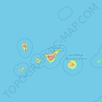
Name: Canary Islands topographic map, elevation, terrain.

Location: Canary Islands, Spain (27.63774 -18.16087 29.41606 -13.33201)

Average elevation: 16 m

Minimum elevation: 0 m

Maximum elevation: 3,500 m

Other topographic maps

Click on a map to view its topography, its elevation and its terrain.

Majorca

Spain > Balearic Islands

Mallorca and the other Balearic Islands are geologically an extension of the fold mountains of the Betic Cordillera of Andalusia. They consist primarily of sediments deposited in the Tethys Sea during the Mesozoic era. These marine deposits have given rise to calcareous rocks which are often fossiliferous. The…

Average elevation: 61 m

Gran Canaria

Spain

Gran Canaria is located in the Atlantic Ocean in a region known as Macaronesia about 150 kilometres (93 mi) off the northwestern coast of Africa and about 1,350 km (840 mi) from Europe. With an area of 1,560 km2 (602 sq. mi) and an altitude of 1,956 m (6,417 ft) at Morro de la Agujereada, Gran Canaria is the…

Average elevation: 335 m

Lanzarote

Spain

Average elevation: 35 m

Barcelona

Spain > Catalonia > Barcelonès

Average elevation: 65 m

Madrid

Spain > Community of Madrid

Madrid lies in the centre of the Iberian peninsula on the southern Meseta Central, 60 km south of the Guadarrama mountain range and straddling the Jarama and Manzanares river sub-drainage basins, in the wider Tagus River catchment area. With an average altitude of 650 metres (2,130 ft), Madrid is the second…

Average elevation: 671 m

Tenerife

Spain

Teide National Park, located in the center of the island, is also a UNESCO World Heritage Site. It includes Mount Teide, which has the highest elevation in Spain, and the highest among all the islands in the Atlantic Ocean. It is also the third-largest volcano in the world, when measured from its base. Another…

Average elevation: 281 m

Alicante

Spain > Valencian Community

Average elevation: 143 m

Seville

Spain > Andalusia

Seville has an area of 141 km2 (54 sq mi), according to the National Topographic Map (Mapa Topográfico Nacional) series from the Instituto Geográfico Nacional – Centro Nacional de Información Geográfica, the country's civilian survey organisation (pages 984, 985 and 1002). The city is situated in the…

Average elevation: 35 m

La Palma

Spain

In a programme transmitted by the British Broadcasting Corporation BBC Horizon broadcast on 12 October 2000, two geologists (Day and McGuire) cited La Grieta as proof that half of the Cumbre Vieja had moved towards the Atlantic Ocean (Day et al. 1999, and Ward and Day, 2001). They postulate that this process…

Average elevation: 296 m

Ibiza

Spain > Balearic Islands > Ibiza

Average elevation: 52 m

Iberian Peninsula

Spain

The Iberian Peninsula encompasses 583,254 km2 and has very contrasting and uneven relief. The mountain ranges of the Iberian Peninsula are mainly distributed from west to east, and in some cases reach altitudes of approximately 3000 mamsl, resulting in the region having the second highest mean altitude (637…

Average elevation: 351 m

Marbella

Spain > Andalusia > Costa del Sol Occidental

There are five geomorphological units: the Sierra Blanca, the Sierra Blanca piedmont (foothills), the lower hill country, the plains and the coastal dunes. The Sierra Blanca is most centrally located in the province, looming over the old village. This mountain range has three peaks: La Concha, located further…

Average elevation: 216 m

Andalusia

Spain

Andalusia sits at a latitude between 36° and 38° 44' N, in the warm-temperate region. In general, it experiences a hot-summer Mediterranean climate, with dry summers influenced by the Azores High, but subject to occasional torrential rains and extremely hot temperatures. In the winter, the tropical…

Average elevation: 378 m

Palma

Spain > Balearic Islands

Palma is a major city and seaport located in the southwest of Mallorca, a western Mediterranean island belonging to the Balearic Islands archipelago. The land area of the city is about 21.355 square kilometres (8.245 sq mi) with an altitude of 13 metres (43 feet) above sea level.

Average elevation: 49 m

Catalonia

Spain

In the Mediterranean area, summers are dry and hot with sea breezes, and the maximum temperature is around 26–31 °C (79–88 °F). Winter is cool or slightly cold depending on the location. It snows frequently in the Pyrenees, and it occasionally snows at lower altitudes, even by the coastline. Spring and…

Average elevation: 559 m

Granada

Spain > Andalusia > Comarca de la Vega de Granada

Granada (Spanish: [ɡɾaˈnaða], locally [ɡɾaˈna]) is the capital city of the province of Granada, in the autonomous community of Andalusia, Spain. Granada is located at the foot of the Sierra Nevada mountains, at the confluence of four rivers, the Darro, the Genil, the Monachil and the Beiro. Ascribed to…

Average elevation: 829 m

Menorca

Spain > Balearic Islands > Es Migjorn Gran

Average elevation: 9 m

Málaga

Spain > Andalusia > Málaga-Costa del Sol

Like many of the military fortifications that were constructed in Islamic Spain, the Alcazaba of Málaga featured a quadrangular plan. It was protected by an outer and inner wall, both supported by rectangular towers, between which a covered walkway led up the slope to the Gibralfaro (this was the only…

Average elevation: 276 m

Orba

Spain > Valencian Community

Average elevation: 267 m

Guadarrama

Spain > Community of Madrid

Average elevation: 1,106 m

Cales de Mallorca

Spain > Balearic Islands > Llevant

Average elevation: 25 m

Ronda

Spain > Andalusia > Serranía de Ronda

Average elevation: 801 m

Pandenes

Spain > Cabranes

Average elevation: 376 m

Lugo

Spain > Galicia > Lugo

The town lies on a hill surrounded by the rivers Miño, Rato and Chanca. The difference in altitude between the city centre and the river banks is considerable: the former being at an altitude of 465 meters above sea level, whilst the Miño River Walk is at an altitude of only 364 metres (1,194 feet). The…

Average elevation: 436 m

Fuerteventura

Spain

Average elevation: 44 m

Girona

Spain > Catalonia > Gironès

Average elevation: 135 m

Oviedo

Spain > Asturias

Oviedo is located in the centre of Asturias between the Nalón River and Nora River. To the north lie Las Regueras and Llanera, to the south Mieres and Ribera de Arriba, to the east Siero and Langreo, and to the west Grado and Santo Adriano. The altitude of Oviedo is between 80 and 709 metres above sea level.…

Average elevation: 284 m

Tegueste

Spain

Average elevation: 464 m

Montjuïc

Spain > Catalonia > Barcelonès > Barcelona

Average elevation: 39 m

Maceda

Spain > Galicia > Allariz-Maceda

Average elevation: 657 m

Salamanca

Spain > Castile and León

With an altitude of over 800 meters, Salamanca has a warm-summer Mediterranean climate (Csb) according to the Köppen climate classification, with some cold semi-arid climate (BSk) climatic influences, resulting in large diurnal temperature variations, with hot summers and chilly winters, and nearly-semi-arid…

Average elevation: 812 m

Murcia

Spain > Region of Murcia > Área Metropolitana de Murcia

Murcia is located near the center of a low-lying fertile plain known as the huerta (orchard or vineyard) of Murcia. The Segura River and its right-hand tributary, the Guadalentín, run through the area. The city has an elevation of 43 metres (141 ft) above sea level and its municipality covers approximately…

Average elevation: 171 m

Villena

Spain > Valencian Community

Average elevation: 664 m

ses Salines

Spain > Balearic Islands > Migjorn

Average elevation: 32 m

Tuineje

Spain

Average elevation: 155 m

Burgos

Spain > Castile and León

At an elevation of 865 metres (2,838 ft), the city of Burgos lies in the transition zone between a Warm-summer Mediterranean climate (Köppen Csb) and an Oceanic climate (Köppen Cfb), with some continental influence resulting from its distance from the sea and higher altitude. Burgos' climate features chilly…

Average elevation: 907 m

les Canotes

Spain > Segrià > Almatret

Average elevation: 145 m

Pico Anayet

Spain > Aragon > Alto Gállego > Sallent de Gállego

Average elevation: 2,176 m

Cala de Bou

Spain > Balearic Islands > Ibiza

Average elevation: 23 m

Cuacos de Yuste

Spain > Extremadura

Average elevation: 553 m

Cangas de Onís

Spain > Asturias

Average elevation: 591 m

Castuera

Spain > Extremadura

Average elevation: 419 m

Pradeda

Spain > Galicia > Chantada

Average elevation: 670 m

El Monte

Spain > Andalusia > La Rambla

Average elevation: 285 m

Amieva

Spain

Average elevation: 916 m

Costa Brava

Spain

Average elevation: 247 m