
Make a donation
Gear up for your next adventure:
As an Amazon Associate, this site earns from qualifying purchases at no extra cost to you.
Sandy Township topographic map
Click on the map to display elevation.
Make a donation
Gear up for your next adventure:
As an Amazon Associate, this site earns from qualifying purchases at no extra cost to you.
About this map
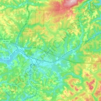
Name: Sandy Township topographic map, elevation, terrain.
Average elevation: 498 m
Minimum elevation: 415 m
Maximum elevation: 685 m
Make a donation
Gear up for your next adventure:
As an Amazon Associate, this site earns from qualifying purchases at no extra cost to you.
Other topographic maps
Click on a map to view its topography, its elevation and its terrain.
Make a donation
Gear up for your next adventure:
As an Amazon Associate, this site earns from qualifying purchases at no extra cost to you.
Morrisdale
United States > Pennsylvania > Clearfield County > Morris Township
Average elevation: 486 m
Make a donation
Gear up for your next adventure:
As an Amazon Associate, this site earns from qualifying purchases at no extra cost to you.
Frenchville
United States > Pennsylvania > Clearfield County > Covington Township
Average elevation: 438 m
Pottersdale
United States > Pennsylvania > Clearfield County > Karthaus Township
Average elevation: 394 m
Mount Hope
United States > Pennsylvania > Clearfield County > Lawrence Township
Average elevation: 419 m
Make a donation
Gear up for your next adventure:
As an Amazon Associate, this site earns from qualifying purchases at no extra cost to you.
Make a donation
Gear up for your next adventure:
As an Amazon Associate, this site earns from qualifying purchases at no extra cost to you.
Utahville
United States > Pennsylvania > Clearfield County > Beccaria Township > Utahville
Average elevation: 503 m