
Zaporizhzhia topographic map
Interactive map
Click on the map to display elevation.
About this map
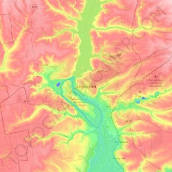
Name: Zaporizhzhia topographic map, elevation, terrain.
Average elevation: 83 m
Minimum elevation: -43 m
Maximum elevation: 140 m
The city is located in south-eastern Ukraine. The Dnieper river splits the city for two parts between them is located the Khortytsia island. The city covers 334 km2 at an elevation of 50 m above sea level.
Other topographic maps
Click on a map to view its topography, its elevation and its terrain.
Дніпровський район
Ukraine > Zaporizhia Oblast > Zaporizhzhia
Дніпровський район, Zaporizhzhia, Zaporizhzhia Urban Hromada, Zaporizhia Raion, Zaporizhia Oblast, Ukraine
Average elevation: 71 m
View on Dnipro Hydroelectric Power Plant
Ukraine > Zaporizhia Oblast > Zaporizhzhia
View on Dnipro Hydroelectric Power Plant, Тарасова Стежка, Вознесенівський район, Zaporizhzhia, Zaporizhzhia Urban Hromada, Zaporizhia Raion, Zaporizhia Oblast, 69065, Ukraine
Average elevation: 45 m