Geolocate

Solca topographic map

Click on the map to display elevation.

About this map

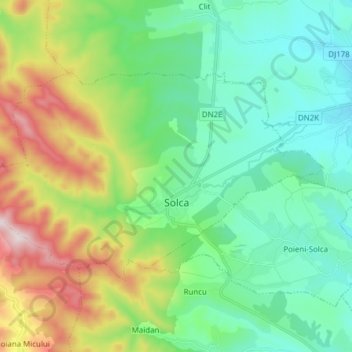
Name: Solca topographic map, elevation, terrain.

Location: Solca, Suceava, 725600, Romania (47.67693 25.74792 47.73821 25.90161)

Average elevation: 574 m

Minimum elevation: 380 m

Maximum elevation: 1,050 m

Gear up for your next adventure:

🌦️Portable Weather Meters - Handheld tools for monitoring weather conditions
🧭Emergency Beacons - Safety beacons for remote outdoor locations
🛰️Satellite Messengers - Emergency communication devices for areas without mobile signal
🧊Personal Water Filters - Drink safely from mountain streams marked on your map
📚UK Hiking Guidebooks - Detailed route descriptions for the Lake District, Peaks, and Highlands

As an Amazon Associate, this site earns from qualifying purchases at no extra cost to you.