
Thank you for supporting this site ❤️
Make a donation
Make a donation
Gear up for your next adventure:
As an Amazon Associate, this site earns from qualifying purchases at no extra cost to you.
waterfall topographic map
Click on the map to display elevation.
Thank you for supporting this site ❤️
Make a donation
Make a donation
Gear up for your next adventure:
As an Amazon Associate, this site earns from qualifying purchases at no extra cost to you.
About this map
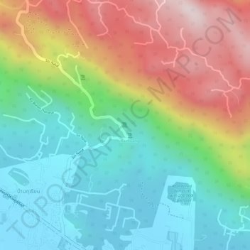
Name: waterfall topographic map, elevation, terrain.
Location: waterfall, Ko Samui, Surat Thani Province, 84310, Thailand (9.46256 100.00746 9.46266 100.00756)
Average elevation: 217 m
Minimum elevation: 10 m
Maximum elevation: 538 m
Thank you for supporting this site ❤️
Make a donation
Make a donation
Gear up for your next adventure:
As an Amazon Associate, this site earns from qualifying purchases at no extra cost to you.