Vangunu topographic map
Interactive map
Click on the map to display elevation.
About this map
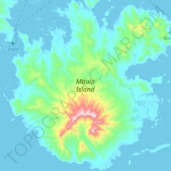
Name: Vangunu topographic map, elevation, terrain.
Location: Vangunu, Western Province, Solomon Islands (-8.77300 157.86907 -8.51292 158.12771)
Average elevation: 113 m
Minimum elevation: -4 m
Maximum elevation: 1,046 m
Other topographic maps
Click on a map to view its topography, its elevation and its terrain.
Vella Lavella
Solomon Islands > Western Province
Vella Lavella, Western Province, Solomon Islands
Average elevation: 58 m
Rendova Island
Solomon Islands > Western Province
Rendova Island, Western Province, Solomon Islands
Average elevation: 69 m
Kolombangara
Solomon Islands > Western Province
Kolombangara, Western Province, Solomon Islands
Average elevation: 198 m
New Georgia
Solomon Islands > Western Province
New Georgia, Western Province, Solomon Islands
Average elevation: 63 m