
Make a donation
Gear up for your next adventure:
As an Amazon Associate, this site earns from qualifying purchases at no extra cost to you.
Sarangkot topographic map
Click on the map to display elevation.
Make a donation
Gear up for your next adventure:
As an Amazon Associate, this site earns from qualifying purchases at no extra cost to you.
Sarangkot
The Ward is located on Sarangkot, a hill on the western side of Pokhara with an altitude of 1600m. Sarangkot is known for its panoramic Himalayan views of Dhaulagiri, Annapurna and Manaslu. It also provides an expansive view of the city of Pokhara, from the extreme north to the south including Phewa Lake. Tourists drive up the hill to watch the sunrise from the view tower at the top. In recent years, Sarangkot has been called one of the best paragliding locations in the world. The hike up from the Pokhara Baglung highway at Miruwa to Sarangkot takes 90 minutes to 1.5hours.
Make a donation
Gear up for your next adventure:
As an Amazon Associate, this site earns from qualifying purchases at no extra cost to you.
About this map
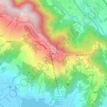
Name: Sarangkot topographic map, elevation, terrain.
Location: Sarangkot, Pokhara, Kaski, Gandaki Province, 33700, Nepal (28.22452 83.92765 28.26452 83.96765)
Average elevation: 1,139 m
Minimum elevation: 795 m
Maximum elevation: 1,657 m
Make a donation
Gear up for your next adventure:
As an Amazon Associate, this site earns from qualifying purchases at no extra cost to you.
Other topographic maps
Click on a map to view its topography, its elevation and its terrain.
Hadeban Upabhokta Samiti , Lamachaur -19
Nepal > Gandaki Province > Kaski > Pokhara
Average elevation: 1,042 m
Make a donation
Gear up for your next adventure:
As an Amazon Associate, this site earns from qualifying purchases at no extra cost to you.