
Ratzeburg topographic map
Interactive map
Click on the map to display elevation.
About this map
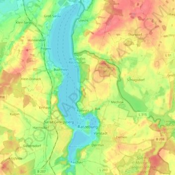
Name: Ratzeburg topographic map, elevation, terrain.
Average elevation: 39 m
Minimum elevation: -1 m
Maximum elevation: 88 m
Die Wahlbeteiligung lag bei 45,6 % und ist damit etwas höher als 2018.
Other topographic maps
Click on a map to view its topography, its elevation and its terrain.
Lüchow
Deutschland > Schleswig-Holstein > Herzogtum Lauenburg
Lüchow, Sandesneben-Nusse, Herzogtum Lauenburg, Schleswig-Holstein, Deutschland
Average elevation: 47 m
Geesthacht
Deutschland > Schleswig-Holstein > Herzogtum Lauenburg
Geesthacht, Herzogtum Lauenburg, Schleswig-Holstein, 21502, Deutschland
Average elevation: 27 m
Gülzow
Deutschland > Schleswig-Holstein > Herzogtum Lauenburg
Gülzow, Schwarzenbek-Land, Herzogtum Lauenburg, Schleswig-Holstein, Deutschland
Average elevation: 46 m