
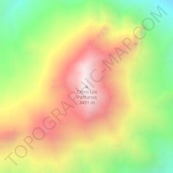
Cerro Los Pantanos topographic map
Interactive map
Click on the map to display elevation.
About this map
Name: Cerro Los Pantanos topographic map, elevation, terrain.
Average elevation: 2,908 m
Minimum elevation: 2,313 m
Maximum elevation: 3,481 m
Other topographic maps
Click on a map to view its topography, its elevation and its terrain.
Cordillera de los Andes
Cordillera de los Andes, Distrito Las Cuevas, Departamento Las Heras, Mendoza, Argentina
Average elevation: 6,208 m
Volcán Tupungato
Volcán Tupungato, Distrito Santa Clara, Departamento Tunuyán, Mendoza, Argentina
Average elevation: 6,003 m