Geolocate

Little Baddow topographic map

Click on the map to display elevation.

About this map

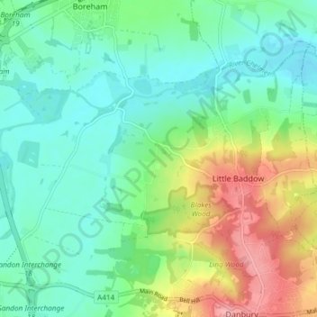
Name: Little Baddow topographic map, elevation, terrain.

Location: Little Baddow, Chelmsford, Essex, England, United Kingdom (51.72186 0.52134 51.75589 0.59513)

Average elevation: 42 m

Minimum elevation: 9 m

Maximum elevation: 113 m

England trails, hiking, mountain biking, running and outdoor activities

Other topographic maps

Click on a map to view its topography, its elevation and its terrain.

Danbury

United Kingdom > England > Chelmsford > Danbury

Average elevation: 62 m

Gear up for your next adventure:

🧴Sport Sunscreen Sticks - High-protection sunblock that won't run into your eyes on the trail
Insulated Travel Mugs - Keep drinks hot while surveying the landscape from a summit
👟Men's Trail Running Shoes - Lightweight grip for fast movement over topographic contours
🧤Thermal Touchscreen Gloves - Stay warm while operating your GPS or smartphone camera
🌄Outdoor Binoculars - Compact binoculars for landscape observation

As an Amazon Associate, this site earns from qualifying purchases at no extra cost to you.