
Spartansburg topographic map
Interactive map
Click on the map to display elevation.
About this map
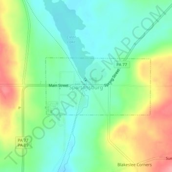
Name: Spartansburg topographic map, elevation, terrain.
Location: Spartansburg, Crawford County, Pennsylvania, United States (41.81954 -79.69392 41.82855 -79.67178)
Average elevation: 463 m
Minimum elevation: 428 m
Maximum elevation: 524 m
Spartansburg Borough is located on the glaciated plateau of northwestern Pennsylvania. The borough is drained by East Branch Oil Creek, which begins at the outlet of Clear Lake, an impoundment of Patrick Run and Stranahan Run. The lowest elevation in Spartansburg is 1,430 ft (440 m) where East Branch Oil Creek flows south out of the borough. The highest elevation is 1,640 ft (500 m) at the southeastern corner of the borough.