
Make a donation
Gear up for your next adventure:
As an Amazon Associate, this site earns from qualifying purchases at no extra cost to you.
Richmond topographic map
Click on the map to display elevation.
Make a donation
Gear up for your next adventure:
As an Amazon Associate, this site earns from qualifying purchases at no extra cost to you.
About this map
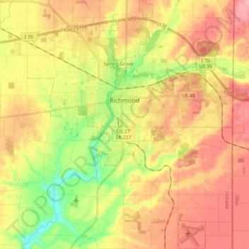
Name: Richmond topographic map, elevation, terrain.
Location: Richmond, Wayne County, Indiana, 47374, United States (39.74859 -84.96375 39.88259 -84.81377)
Average elevation: 314 m
Minimum elevation: 247 m
Maximum elevation: 372 m
Make a donation
Gear up for your next adventure:
As an Amazon Associate, this site earns from qualifying purchases at no extra cost to you.
Other topographic maps
Click on a map to view its topography, its elevation and its terrain.
Hoosier Hill
United States > Indiana > Wayne County
Hoosier Hill is the highest natural point in the U.S. state of Indiana with a claimed elevation of 1,257 feet (383 meters) above sea level. Hoosier Hill's claimed elevation is based on SRTM digital elevation data which is now considered to be outdated. Using newer elevation tools such as USGS's 3DEP, the top…
Average elevation: 373 m