
Make a donation
Gear up for your next adventure:
As an Amazon Associate, this site earns from qualifying purchases at no extra cost to you.
Namche Bazaar topographic map
Click on the map to display elevation.
Make a donation
Gear up for your next adventure:
As an Amazon Associate, this site earns from qualifying purchases at no extra cost to you.
Namche Bazaar
Namche Bazaar is popular with trekkers in the Khumbu region, especially for altitude acclimatization, and is the gateway to the high Himalaya. The town has a number of lodgings and stores catering to the needs of visitors as well as a number of internet cafés. There are German bakeries, little cafes and many restaurants. There is also an Irish pub, said to be the highest and most remote Irish pub in the world. A popular local meal is yak steak.
Make a donation
Gear up for your next adventure:
As an Amazon Associate, this site earns from qualifying purchases at no extra cost to you.
About this map
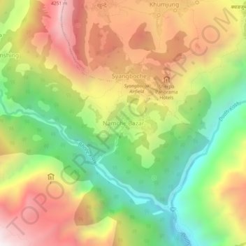
Name: Namche Bazaar topographic map, elevation, terrain.
Average elevation: 3,526 m
Minimum elevation: 2,810 m
Maximum elevation: 4,294 m
Make a donation
Gear up for your next adventure:
As an Amazon Associate, this site earns from qualifying purchases at no extra cost to you.
Other topographic maps
Click on a map to view its topography, its elevation and its terrain.
Make a donation
Gear up for your next adventure:
As an Amazon Associate, this site earns from qualifying purchases at no extra cost to you.