
Make a donation
Gear up for your next adventure:
As an Amazon Associate, this site earns from qualifying purchases at no extra cost to you.
High Cup Nick topographic map
Click on the map to display elevation.
Make a donation
Gear up for your next adventure:
As an Amazon Associate, this site earns from qualifying purchases at no extra cost to you.
High Cup Nick
The Pennine Way skirts the valley on its northern side by a traditional route known as Narrow Gate as it runs from Forest in Teesdale west via Cauldron Snout and Maize Beck to Dufton. This national trail briefly splits into two separate routes on either bank of Maize Beck; it is the southerly of the two which leads via High Cup Nick. Listed in the 100 best Pathfinder walks in Britain, High Cup Nick has been described as a difficult walk of 8 miles (13 km), with an elevation of 1,445 feet (440 m). The famous fellwalker Alfred Wainwright describes High Cup as "a great moment on the journey" in his book Pennine Way Companion.
Make a donation
Gear up for your next adventure:
As an Amazon Associate, this site earns from qualifying purchases at no extra cost to you.
About this map
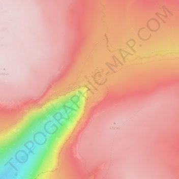
Name: High Cup Nick topographic map, elevation, terrain.
Average elevation: 601 m
Minimum elevation: 324 m
Maximum elevation: 694 m
Cumbria trails, hiking, mountain biking, running and outdoor activities
Make a donation
Gear up for your next adventure:
As an Amazon Associate, this site earns from qualifying purchases at no extra cost to you.