
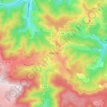
Mézilhac topographic map
Interactive map
Click on the map to display elevation.
About this map
Name: Mézilhac topographic map, elevation, terrain.
Average elevation: 1,101 m
Minimum elevation: 714 m
Maximum elevation: 1,421 m
Der Ort befindet sich im südöstlichen Zentralmassiv auf über 1100 Metern Höhe auf dem Gebirgspass Col de Mézilhac zwischen Aubenas und Le Cheylard, an der Kreuzung mehrerer lokaler Verbindungsstraßen. Die Volane, ein Zufluss der Ardèche, entspringt auf dem Gebiet der Gemeinde.