
Make a donation
Gear up for your next adventure:
As an Amazon Associate, this site earns from qualifying purchases at no extra cost to you.
Ressaix topographic map
Click on the map to display elevation.
Make a donation
Gear up for your next adventure:
As an Amazon Associate, this site earns from qualifying purchases at no extra cost to you.
About this map
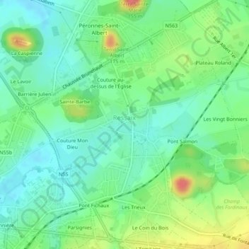
Name: Ressaix topographic map, elevation, terrain.
Location: Ressaix, Binche, La Louvière, Hainaut, Wallonie, 7134, Belgique (50.40971 4.17450 50.43640 4.21052)
Average elevation: 107 m
Minimum elevation: 83 m
Maximum elevation: 156 m
Make a donation
Gear up for your next adventure:
As an Amazon Associate, this site earns from qualifying purchases at no extra cost to you.
Other topographic maps
Click on a map to view its topography, its elevation and its terrain.
Leval-Trahegnies
Belgique > Hainaut > La Louvière > Binche > Leval-Trahegnies
Average elevation: 140 m
Couture au-dessus de l'Église
Belgique > Hainaut > La Louvière > Binche > Ressaix
Average elevation: 103 m
Make a donation
Gear up for your next adventure:
As an Amazon Associate, this site earns from qualifying purchases at no extra cost to you.
Make a donation
Gear up for your next adventure:
As an Amazon Associate, this site earns from qualifying purchases at no extra cost to you.
Make a donation
Gear up for your next adventure:
As an Amazon Associate, this site earns from qualifying purchases at no extra cost to you.