
Rongkop topographic map
Interactive map
Click on the map to display elevation.
About this map
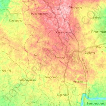
Name: Rongkop topographic map, elevation, terrain.
Average elevation: 308 m
Minimum elevation: 123 m
Maximum elevation: 471 m
Other topographic maps
Click on a map to view its topography, its elevation and its terrain.
Pantai Drini
Indonesia > Special Region of Yogyakarta > Gunung Kidul Regency > Banjarejo
Average elevation: 20 m
Gedangan
Indonesia > Special Region of Yogyakarta > Gunung Kidul Regency > Gedangsari > Hargomulyo
Average elevation: 325 m
Pantai Ngandong
Indonesia > Special Region of Yogyakarta > Gunung Kidul Regency > Sidoharjo
Average elevation: 23 m
Karang Sari
Indonesia > Special Region of Yogyakarta > Gunung Kidul Regency > Karangsari
Average elevation: 348 m
Pantai Krakal Barat
Indonesia > Special Region of Yogyakarta > Gunung Kidul Regency > Kanigoro
Average elevation: 27 m
Ngasemayu
Indonesia > Special Region of Yogyakarta > Gunung Kidul Regency > Patuk
Average elevation: 222 m
Pantai Porok
Indonesia > Special Region of Yogyakarta > Gunung Kidul Regency > Kemadang
Average elevation: 20 m
Sepanjang Beach
Indonesia > Special Region of Yogyakarta > Gunung Kidul Regency > Kemadang
Average elevation: 15 m
Pantai Jungwok
Indonesia > Special Region of Yogyakarta > Gunung Kidul Regency > Jepitu
Average elevation: 15 m
Ngoro Oro
Indonesia > Special Region of Yogyakarta > Gunung Kidul Regency > Ngoro-oro > Ngoro Oro
Average elevation: 291 m