
Sortes topographic map
Interactive map
Click on the map to display elevation.
About this map
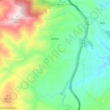
Name: Sortes topographic map, elevation, terrain.
Location: Sortes, Bragança, Portugal (41.67343 -6.88391 41.72030 -6.80540)
Average elevation: 855 m
Minimum elevation: 629 m
Maximum elevation: 1,314 m
Other topographic maps
Click on a map to view its topography, its elevation and its terrain.
Montesinho Nature Park
Portugal > Bragança > Bragança > Espinhosela
Montesinho Nature Park, Espinhosela, Bragança, 5300-245, Portugal
Average elevation: 881 m