
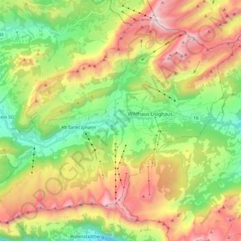
Wildhaus-Alt St. Johann topographic map
Interactive map
Click on the map to display elevation.
About this map
Name: Wildhaus-Alt St. Johann topographic map, elevation, terrain.
Average elevation: 1,453 m
Minimum elevation: 718 m
Maximum elevation: 2,479 m
Other topographic maps
Click on a map to view its topography, its elevation and its terrain.
Gähwil
Switzerland > St. Gallen > Wahlkreis Toggenburg > Kirchberg (SG)
Gähwil, Kirchberg (SG), Wahlkreis Toggenburg, St. Gallen, 9534, Switzerland
Average elevation: 778 m
Riet
Switzerland > St. Gallen > Wahlkreis Toggenburg > Bütschwil-Ganterschwil > Bütschwil
Riet, Bütschwil, Bütschwil-Ganterschwil, Wahlkreis Toggenburg, St. Gallen, 9606, Switzerland
Average elevation: 687 m
Mühlrüti
Switzerland > St. Gallen > Wahlkreis Toggenburg > Mosnang
Mühlrüti, Mosnang, Wahlkreis Toggenburg, St. Gallen, 9613, Switzerland
Average elevation: 829 m
St. Peterzell
Switzerland > St. Gallen > Wahlkreis Toggenburg > Neckertal > St. Peterzell
St. Peterzell, Neckertal, Wahlkreis Toggenburg, St. Gallen, Switzerland
Average elevation: 857 m