
Thank you for supporting this site ❤️
Make a donation
Make a donation
Gear up for your next adventure:
As an Amazon Associate, this site earns from qualifying purchases at no extra cost to you.
Remolinos topographic map
Click on the map to display elevation.
Thank you for supporting this site ❤️
Make a donation
Make a donation
Gear up for your next adventure:
As an Amazon Associate, this site earns from qualifying purchases at no extra cost to you.
About this map
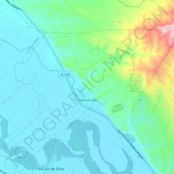
Name: Remolinos topographic map, elevation, terrain.
Location: Remolinos, Ribera Alta del Ebro, Zaragoza, Aragon, Spain (41.81664 -1.21312 41.86998 -1.12951)
Average elevation: 289 m
Minimum elevation: 213 m
Maximum elevation: 620 m
Thank you for supporting this site ❤️
Make a donation
Make a donation
Gear up for your next adventure:
As an Amazon Associate, this site earns from qualifying purchases at no extra cost to you.