Geolocate

Moncarapacho topographic map

Click on the map to display elevation.

About this map

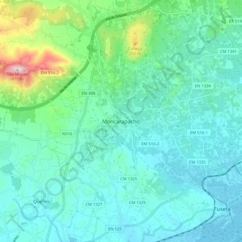
Name: Moncarapacho topographic map, elevation, terrain.

Location: Moncarapacho, Olhão, Faro, 8700-095, Portugal (37.04421 -7.82825 37.12421 -7.74825)

Average elevation: 75 m

Minimum elevation: -1 m

Maximum elevation: 408 m

Other topographic maps

Click on a map to view its topography, its elevation and its terrain.

Quelfes

Portugal > Faro > Olhão

Average elevation: 25 m

Pechão

Portugal > Faro > Olhão

Average elevation: 28 m

Moncarapacho

Portugal > Faro > Olhão

Average elevation: 59 m

Moncarapacho

Portugal > Faro > Olhão

Average elevation: 59 m

Fuseta

Portugal > Faro > Olhão

Average elevation: 5 m

Ilha da Armona

Portugal > Faro > Olhão > Moncarapacho

Average elevation: 6 m

Gear up for your next adventure:

🔥Reusable Hand Warmers - Maintain dexterity in your fingers for precise map handling
👟Men's Trail Running Shoes - Lightweight grip for fast movement over topographic contours
🖼️Topographic Map Art - Decorative 3D-effect posters of famous UK peaks and regions
📸Action Camera Chest Mounts - Record your ascent following topographic paths hands-free
🧷Tenacious Repair Tape - Instant fix for torn tents, jackets, or dry bags

As an Amazon Associate, this site earns from qualifying purchases at no extra cost to you.