
Make a donation
Gear up for your next adventure:
As an Amazon Associate, this site earns from qualifying purchases at no extra cost to you.
Thornham topographic map
Click on the map to display elevation.
Make a donation
Gear up for your next adventure:
As an Amazon Associate, this site earns from qualifying purchases at no extra cost to you.
About this map
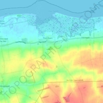
Name: Thornham topographic map, elevation, terrain.
Average elevation: 24 m
Minimum elevation: -2 m
Maximum elevation: 73 m
Norfolk trails, hiking, mountain biking, running and outdoor activities
Make a donation
Gear up for your next adventure:
As an Amazon Associate, this site earns from qualifying purchases at no extra cost to you.
Other topographic maps
Click on a map to view its topography, its elevation and its terrain.
St John's Fen End
United Kingdom > England > Norfolk > King's Lynn and West Norfolk
Average elevation: 1 m
Brandon Bank
United Kingdom > England > Norfolk > King's Lynn and West Norfolk > Feltwell
Average elevation: -1 m
Make a donation
Gear up for your next adventure:
As an Amazon Associate, this site earns from qualifying purchases at no extra cost to you.
Great Bircham
United Kingdom > England > Norfolk > King's Lynn and West Norfolk
Average elevation: 61 m
Make a donation
Gear up for your next adventure:
As an Amazon Associate, this site earns from qualifying purchases at no extra cost to you.
Bircham Tofts
United Kingdom > England > Norfolk > King's Lynn and West Norfolk > Great Bircham
Average elevation: 63 m
Brancaster Staithe
United Kingdom > England > Norfolk > King's Lynn and West Norfolk
Average elevation: 18 m
Methwold Hythe
United Kingdom > England > Norfolk > King's Lynn and West Norfolk > Methwold
Average elevation: 8 m
Flaxley
United Kingdom > England > Norfolk > King's Lynn and West Norfolk > Holme next the Sea
Average elevation: 8 m
Make a donation
Gear up for your next adventure:
As an Amazon Associate, this site earns from qualifying purchases at no extra cost to you.
Old Hunstanton Lighthouse
United Kingdom > England > Norfolk > King's Lynn and West Norfolk > Hunstanton > Old Hunstanton
Average elevation: 9 m
Walpole St Andrew
United Kingdom > England > Norfolk > King's Lynn and West Norfolk
Average elevation: 3 m
Ely-Ouse-Essex Water Transfer Scheme
United Kingdom > England > Norfolk > King's Lynn and West Norfolk > Hockwold cum Wilton
Average elevation: 4 m
Make a donation
Gear up for your next adventure:
As an Amazon Associate, this site earns from qualifying purchases at no extra cost to you.
St John's Highway
United Kingdom > England > Norfolk > King's Lynn and West Norfolk
Average elevation: 2 m
Sandringham Estate
United Kingdom > England > Norfolk > King's Lynn and West Norfolk > Sandringham
Average elevation: 25 m
Make a donation
Gear up for your next adventure:
As an Amazon Associate, this site earns from qualifying purchases at no extra cost to you.
Walton Highway
United Kingdom > England > Norfolk > King's Lynn and West Norfolk
Average elevation: 3 m
Denver Sluice
United Kingdom > England > Norfolk > King's Lynn and West Norfolk > Downham Market
Average elevation: 2 m
Suspension Bridge
United Kingdom > England > Norfolk > King's Lynn and West Norfolk > Welney > Suspension Bridge
Average elevation: 1 m
Make a donation
Gear up for your next adventure:
As an Amazon Associate, this site earns from qualifying purchases at no extra cost to you.
Old Bedford River
United Kingdom > England > Norfolk > King's Lynn and West Norfolk
Average elevation: 1 m
Marshland St James
United Kingdom > England > Norfolk > King's Lynn and West Norfolk
Average elevation: 1 m
Pott Row
United Kingdom > England > Norfolk > King's Lynn and West Norfolk > Pott Row
Average elevation: 18 m
Saint Hilary Park
United Kingdom > England > Norfolk > King's Lynn and West Norfolk > King's Lynn
Average elevation: 7 m
Make a donation
Gear up for your next adventure:
As an Amazon Associate, this site earns from qualifying purchases at no extra cost to you.
Castle Rising
United Kingdom > England > Norfolk > King's Lynn and West Norfolk > Castle Rising
Average elevation: 22 m